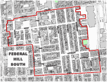
Federal Hill South
National Register of Historic Places: 12/22/03
Description
 The Federal Hill South Historic is an approximately 30 block, 1000 building area in south Baltimore, Situated on the northwest branch of the Patapsco River, the district is generally bounded on the north by the Federal Hill Historic District. On the east by a waterfront redevelopment corridor, on the south by Fort Avenue and Ostend Street, and on the west by Marshall Street and Olive Street. Largely laid out before the 1823 Poppleton Plan, the district has an irregular street grid.
Brick rowhouses (ca. 1830-1900) are the most common building type in this dense neighborhood. Rowhouses are concentrated in the eastern part of the district, where modest two and three-story houses line blocks that cap a waterfront ridge. Rowhouses represent a continuum of development and most blocks include a robust mixture of types. Small groups of identical houses and dramatic topographical changes create undulating cornice lines, emphasizing the vertical arrangement of individual houses over the horizontal arrangement of the unified blockfront.
The steeples of two substantial ca. 1860s Gothic revival Roman Catholic churches soar above the residential skyline. Commercial buildings, the second most common type, are concentrated in the western part of the district. The linear spine of the neighborhood commercial district runs south from Cross Street Market along primary thoroughfares: Light Street, Charles Street, and Fort Avenue.
Small brick commercial buildings (ca. 1830-1900) that mirror residential types are the most common commercial buildings in the district. Larger commercial buildings dating from the 20th century are also seen on Light and South Charles streets. A branch library building, local hospital building, two school buildings, and a police station (constructed in the late 19th and early 20th century) complete the built environment of the commercial section.
Significance
Characterized by dense streetscapes lined with modest rowhouses and commercial structures, the Federal Hills South Historic District mirrors the robust diversity of Baltimore's working class during the period of neighborhood development, ca. 1830-1900. Located at the heart of Baltimore's industrial waterfront. Federal Hill South stands to represent its working class, immigrant population and their successful economic and social strategies. The district's period of significance extends from ca. 1830 to 1945.
First settled by a largely German immigrant population in the 1830's, Federal hill South continued to support an increasingly heterogeneous population through the mid-20th century, when the aftermath of war time booms and post-war out-migration changed the social and cultural character of the district. The Federal Hill South Historic District, whose period of significance extends from ca. 1830 to 1945, is largely intact.
An urban industrial neighborhood, the Federal hill South Historic District meets National Register Criterion A because of its association with Baltimore's working class settlement patterns ca. 1830-1900. Over 95% of the buildings constructed prior to 1945 remain. A specifically Baltimorean assortment of features characterize alterations in the district. Formstone-fronted rowhouses with window displays of religious and sporting iconography often sit cheek-by-jowl with rowhouses with restores facades and roof decks.
Changes to commercial buildings, such as updated storefronts, are typical of the property type. Alterations in the district indicate continuos building use and neighborhood vitality. While individual buildings have been altered, these changes have not affected the integrity of the district as a whole. All-important building massing, forma, and rhythm of the streetscapes remain legible to represent the historic district's identity as an urban industrial neighborhood.